What’s the best way to tell area residents about plans for a new asylum shelter nearby?
The government should tell communities directly about plans for new asylum shelters, some activists and politicians say.
Over the years, many transport experts have challenged authorities with visionary maps of how Dubliners might get proper access to the city they live in. This is a tribute to their ideas.

The reason Dublin’s public transport system is perceived to be, let’s say, not world-beating is nothing to do with the lack of an underground system. The core reason is … transfers. In Dublin we can’t properly do them. We do not have a functioning, legible transport “network”.
Of course there are other reasons for Dublin’s comparatively low public transport mode-share: accessibility and congestion levels cannot be ignored, but they are all linked to the above fact.
Dublin’s public-transport system is largely predicated on key arterial routes that can take you to the city centre. But if you want to go anywhere else, you’d better have a car. And regardless of whether you do or not, expect delays.
The honest reprise of many a Dubliner – that they know their own bus route but haven’t a breeze about any of the others – is basically true. It is a system that has been described by international experts as “too complicated”.
So in Dublin it remains the assumption that either the bus takes you somewhere in a single jump … or go drive.
***
But cities with transport networks that work assume the precise opposite. They expect that most travellers will have to transfer to complete their journey. That is how and why their transport systems work. It’s called the “network effect” and transferring has to be seamless and painless for it to operate at all.
Surprisingly, studies we’ve mentioned before demonstrate that over 25 percent of public transport users in Dublin are making transfers in their journey already. While it is unclear how pleasant, or otherwise, the experience is for these travellers, it is likely that most of them travel all the way to the city centre to be able to find a reliable interchange point. That’s a quarter of city-centre capacity that could be freed up, for cycling and walking, not to speak of more commercial and cultural activity.
All this even after a significant shake-up of bus routes by Dublin Bus. Their 2013 route reorganisation project, called Network Direct, successfully cut the number of bus routes from over 170 to 110 without any loss of ridership. But ridership didn’t hugely grow either, as it might have after such root-and-branch review.
It’s called the “network effect” and transferring has to be seamless and painless for it to operate at all.
Maybe its time for “Network Direct II” then. And, gladly, the National Transport Authority (NTA) appear to have plans for just that.
At a recent talk to Dublin Chambers, Anne Graham, chief executive of the NTA, announced that details of an overall bus plan are to be published “in about two months”, to include three Bus Rapid Transit routes, 11 other radial bus corridors and three orbital bus corridors.
How these are integrated into a coherent network will be fundamental to their success.
***
The science of public-transport network design is an ever emerging field, though some cities are past-masters at it.
Mark Ovenden’s wonderful book of Transit Maps of the World relates how Harry Beck’s world-famous schematic map of the Underground was immediately rejected by the London transport chiefs.
They had no time for his technique of “map distortion” even though it made perfect sense to the eye of the user. They eventually gave in to popular demand and the “tube” map became the defining symbol of one of the world’s greatest cities.
Arrive into Zurich airport as a complete stranger. Within 10 minutes you will have a ticket and a map that will connect you to the entire city with intuitive ease. Zurich has the highest public transport mode share in the world. There is no underground metro in Zurich, just exceptionally good traffic management and a great, legible network.
Barcelona already had a decent public-transport network, but it is revolutionising it again with an elegantly effective new public transport network design. Its aim is to further increase patronage, but it will enable more cycling and walking too.
***
This feature is called “Great Dublin Transport Networks” for a reason.
Over the years, attempts have been made at designing a public-transport network for Dublin. Some of these were by transport advocates, others by those working in a professional capacity – oftentimes both.
All of the designs used “network” thinking as their base. Their concepts challenge the transport authorities to see how Dubliners might truly get proper access to the city they live in.
What follows is both a reminder and a tribute to their efforts. All of these ideas have been published openly in the past, and permissions given to the Dublin Inquirer to reference them here again.
Who knows, perhaps their ideas may yet see the light of day?
The first mention must go to Dr Roy Johnston, for his pre-millennial “Future for Dublin” proposal. This was an essay, map and attempt at reconfiguring the city as it should be: a network of connected villages.
Johnston, who is something of an environmental and political philosopher, wrote his seminal article as long ago as 1991. The scope and scale of the city may have changed, but it reads as fresh and makes as much good sense today as it did back then.
“You could get from anywhere to almost anywhere else over the greater Dublin area with one change.”
Happily, the very far-sighted article is still available to read at Dr Johnston’s blog. In it, Johnston correctly points out that the starting point for planning the transport network is the city and its inherent structure.
Johnston also realises that Dublin is not circular, sort of orbiting around O’Connell Bridge, but rectangular, boxed in by the airport, mountains, sea and the Kildare/Meath plains.
He starts to construct a dense but even “network” based on these principles. In this future vision for Dublin, “You could get from anywhere to almost anywhere else over the greater Dublin area with one change.”
What is extraordinary is that nobody, in the meantime, has asked how we can reach this point, this city that possesses full mobility, a network that is legible, that meets the needs of people and connects neighbourhoods in a way that is efficient and is understood.
It seems that perennially, our decision-making has been dominated by concerns over the capital budget, slices of the cake and the big-ticket items, which, as so often demonstrated, take decades to resolve and usually cloud the real debate – what to do with the city – both publicly and administratively.
The paper and map, both a panacea to the conventional group-think, are accessible on Roy Johnston’s weblog.
Perhaps the most celebrated attempt at visualising a public transport network for Dublin is also the subject of a viral TEDx video.
Popularly known as the “Aris Map”, it is actually the extensive work of Greek/German graphic designer Aris Venetikidis, assisted by James Leahy, who is currently honorary secretary of An Taisce, and operates his own cycle-to-work company, Travel Hub.
It was Aris’ idea to prepare a transit-network map for Dublin using the schematic techniques made world-famous by the London Underground Map. Aris’ map is best explained by himself in the TEDx video “Making Sense of Maps”, which was filmed in Dublin and quickly went viral around the planet. In it, Aris explains how, using map distortion and clear geometric lines, he illustrated a network that is instantly recognisable as the city of Dublin.
Aris’ biggest problem was of course that the real-life network of disconnected, meandering routes was far too incoherent even for an astute graphic designer like himself to unscramble. He turned to James Leahy, a transport advocate, engineer and entrepreneur, who presented him with a viable alternative. Between them they conceived a future network proposal and turned it into a user-friendly network map.
What a pity the actual network itself doesn’t exist. Perhaps, in future, something close to it might.
Joyfully, due to there being renewed interest in Dublin and its dysfunctional transport system, Aris has re-posted his Integrated Map, along with the entire incredible project which explains the underlying concept and design-flow, here.

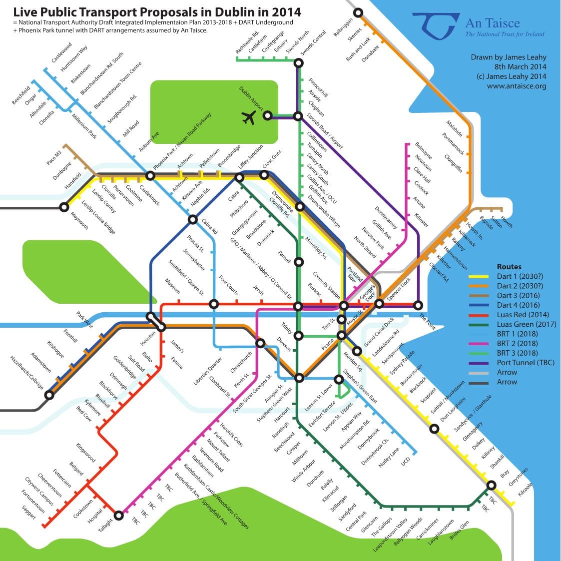
A very viable and serious proposal also involved the work of James Leahy, this time on behalf of An Taisce, the National Trust for Ireland, and in response to various transport plans and proposals by the National Transport Authority, which is the body tasked with actually providing a public-transport network for Dublin.
In 2014 An Taisce published a schematic map – mainly the work of Leahy – of existing proposals by Dublin’s transport agencies. An Taisce were coming out largely in support of the list of public-transport projects in the “Integrated Implementation Plan for the Greater Dublin Area“, and the “Swiftway” Bus Rapid Transit proposals.
To help illustrate their benefits, Leahy published a schematic London Underground-style map of current transport proposals that in his view might realistically happen. The map includes the connected Red and Green Luas lines, the Phoenix Park Tunnel (now blissfully open), Maynooth and Kildare line electrification, and the three “Swiftway” Bus Rapid Transit Routes.
According to Leahy, “These proposals are very exciting because they are affordable and can be quickly constructed”. It is apparent from the map that Dublin could get sufficient transport services to provide an integrated network, allowing people to get to many different places in the city by making “only one or two transfers”.
In Leahy’s own words: “other cities have shown that there is a ‘network effect’ with public transport. Once you have a critical mass of integrated services, then public transport use grows much faster than it does for isolated projects. This can never happen with rail projects alone, in our sprawling low-density city. To compete with other European cities we need to provide a city that is attractive and liveable”. Hear, hear!
The An Taisce Dublin Transport full proposals are available here.
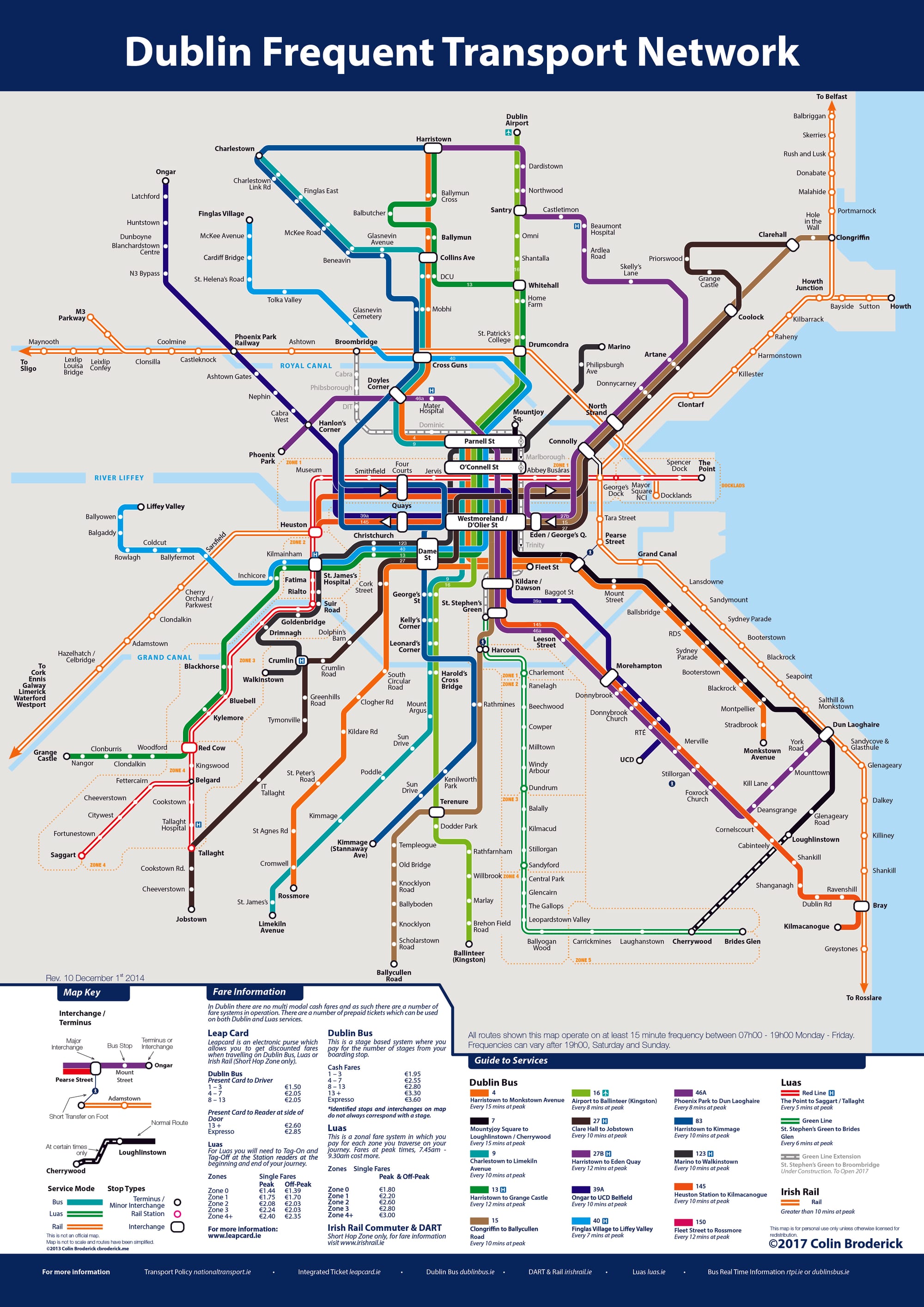
Only one of the maps of Dublin profiled here can actually be used today as a map, proper, to navigate Dublin’s public transport services. It is an open-source production by DIT spatial-planning graduate, Colin Broderick.
Frustrated by the absence of any integrated service map of Dublin, Broderick, a digital-mapping enthusiast, set out to prepare his own. It is according to the map-maker “your only guide to the best of Dublin Transport for only €5 with 12 months updates!”
Broderick’s map is indeed available for a modest purchase (well worth it in our view) here. “Never get the wrong Bus, Train or Luas again!” says Broderick, and what could be wrong with that.
Broderick’s “Dublin Frequent Transport Network” uses graphic-design principles similar to those used by Aris Venetikidis in the “Aris Map”. Except that this is a map of existing services.
It includes only those with a high enough frequency to be considered by anyone who might want to transfer. It selects any existing service with a frequency of 15 minutes or higher.
This presents a very clear picture. Dublin has some key arterial routes, but lacks any quality orbital routes, essential for the “network effect” mentioned earlier.
Perhaps the frequency criteria should have been 10 minutes or higher, but this is a minor quibble with a high-quality map production that shows both the powers of schematic illustration in transit mapping and equally exposes the limitations of Dublin’s existing public-transport service array.
Colin Broderick’s “Dublin Frequent Transport Network” map is available online for a very modest fee here.
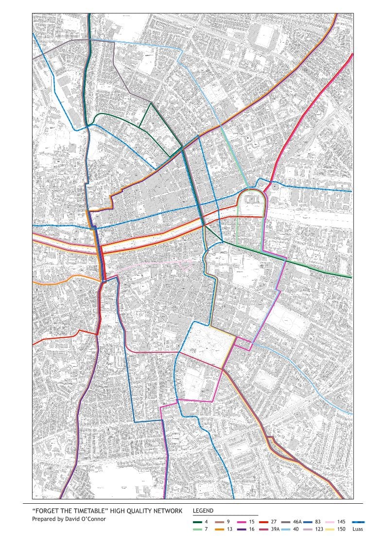
The Irish Georgian Society has been advocating for the preservation of our built heritage since the 1950s, when it was founded in response to the politically motivated abandonment of Dublin’s historic core. While the society is hardly known for designing public-transport networks, it decided it had to give the matter some thought during 2016.
Its concerns were in response to the Dublin City Transport Strategy and associated traffic-management measures for College Green. Neither of these were part of its principle objections – far from it. But there was and remains a warranted concern at the proposed rerouting of a large quantum of bus routes onto Parliament Street.
In a very considered submission, the society argued that, while welcoming the creation of a plaza a College Green, simply moving the problem of bus congestion to the next available river crossing was hardly a satisfactory answer. The society worked together with this author to examine viable alternatives.
A series of maps proposed how a high-frequency city-centre network could be created that would largely circumvent, yet at the same time serve very well, Dublin’s historic city centre.
… it is amazing how much of the city can be freed up for walking, cycling, even access to city-centre car parks.
The proposed solution answers a problem that many of the other mapping problems do not contend with: what to do with the immediate city centre. While not a schematic map, it is based on one of the above maps – that of Colin Broderick’s high-frequency network.
To make the city-centre network work, all other low-frequency services were dropped. Thus, a potential “Forget the Timetable” High Quality Network is conceived, one that should be always there, always on, always accessible to all.
The network is based on 300–400m walkable cells, a modus successfully adopted by both Zurich and Barcelona. Taking this viable and sustainable approach, it is amazing how much of the city can be freed up for walking, cycling, even access to city-centre car parks (once the City Council successfully eliminates unwanted through-trips).
The Irish Georgian Society submission to the College Green Traffic Management Measures Public Consultation, along with accompanying maps, is available here.
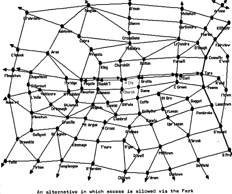
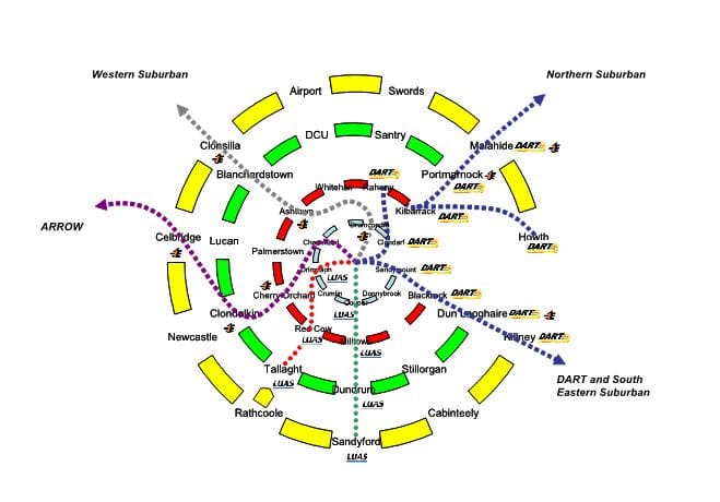
The Network Direct project completed by Dublin Bus in 2013 is often talked about in terms of its comparatively limited success in reducing the number of routes and buses while serving the same number of passengers.
It is seldom acknowledged that this rationalisation was part of a far more ambitious plan conceived by consultants MVA (now Systra) on behalf of Dublin Bus. The MVA/Dublin Bus Strategy is set out in a 2006 study, the “Dublin Bus Network Review”, which remains possibly the best of the many, albeit unimplemented, transport strategies for Dublin.
It is neither MVA’s nor Dublin Bus’s fault that the government decided to implement only the cost-cutting elements of the strategy, dispensing with the vital elements that aimed to grow public-transport patronage and increase mobility in the city.
In addition to consolidating and rethinking a myriad of meandering, low-patronage routes, the strategy proposed a series of high-quality orbital routes, along with express routes, to serve the growth towns in the suburbs. The orbitals made particular sense, connecting up villages and towns in Dublin’s inner and outer suburban areas.
The strategy also had other sensible proposals, such as an important reorganisation of depots.
The report is no longer available online. A key diagram conceptualising the orbital routes is reproduced below.

The government should tell communities directly about plans for new asylum shelters, some activists and politicians say.


The current skirmish is over a Manna base at Junction 6 in Blanchardstown.

The idea is for this spot next to Dublin Castle to host choirs, chamber music, trad music, poetry performances, and more.