“Having private, for-profit care goes against all you are trying to achieve for children in care,” says Terry Dignan, a spokesperson for charities that run children’s homes.
Councils are reluctant to use the single-stage process because they take on more risk if something goes wrong, says Sinn Féin TD and housing spokesperson Eoin Ó Broin.
At The Library Project, Creating Artworks from Google Maps
Three of photographer David Thomas Smith’s works are currently on display at the gallery in Temple Bar, part of a series inspired by a message sent into space.
Photographer David Thomas Smith is dressed in black, 6′ 3″, and enters the Library Project in Temple Bar with tripod in hand.
On a white wall across from the entrance hang three of his works, part of his Arecibo series, which he’s been working on for some time.
There are nine works in total, and Smith had one story in mind for the series: humanity’s exploration and evolution.
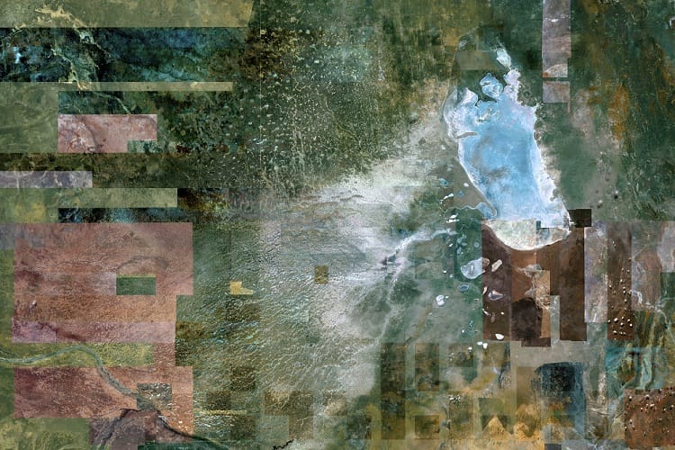
But these works – on show until Sunday – are not straightforward photographs. Each section of each work is taken from Google maps.
They’re essentially composite images, Smith says, laying down his equipment nearby. Each one is created from thousands of JPEGs that he has captured.
“I’ll zoom in, take a screen grab, move along, take another screen grab and then open them up in Photoshop and then reassemble it,” says Smith.
Angola to Apollo
What we’re actually seeing when we look on Google Maps are two separate images, says Smith.
Zoom in on a location on Google Maps and it may appear seamless. But that’s just how the software operates.
The higher-resolution close-up images were taken from a plane, while others are taken from a satellite. Because of the software, they blend seamlessly.
“What you’re looking at here,” says Smith, pointing to his work, “is what a satellite would see but from the quality of the plane image.”
He’s combined the two, in other words, giving a close-up effect, but from a greater height. “It takes a hell of a lot of time,” he laughs. But so did humankind’s evolution.
“Birth of Man”, by David Thomas Smith
Smith’s series of composite photographs – each measuring four feet by six feet – starts with the Birth of Man on the border of Angola and Namibia, moving through to the Neolithic Age in East Africa and the Bronze Age in Egypt.
It can be a painstaking process, hovering over these locations on Google Maps, says Smith. It’s easy to lose your way as you try to capture a particular section if you move off too quickly before screen grabbing.
Forget where you are and forget it, in other words. “You’ve to try find some way of mapping it,” says Smith.
Once he’s captured each image and created his composite, Smith prints out the work in one go, in pretty much the largest size you can print. High-quality acrylic holds the image in place.
“I’ve been working on this for a couple of years,” Smith says, referring to Arecibo.
In River Nile, Egypt, the effect of the two-image combination is striking. From satellite height, there appear to be almost brush strokes on the surface of the photograph.
Each section of the landscape is spliced alongside another image, taken at another time.
Some things even Smith can’t explain. Images captured on Google Maps are taken at different times and in different conditions, he says. That’s what gives the works their multi-coloured, almost distorted effect.
“I couldn’t tell you why some of them change colour, though. Like, this I can’t explain,” says Smith, pointing to a patch of landscape near the Nile that would normally be golden. “Why is that so blue?” He puts it down to weather changes.
A New Context
The title of Smith’s series, Arecibo, is named after the observatory in Arecibo, Puerto Rico. In November 1974, workers there transmitted the so-called “Arecibo message”.
The message, meant for extra-terrestrial life, was transmitted some 25,000 light years away. “However, by the time it was actually meant to get to the M13 [star cluster] it would be gone. So it really was just a, ‘Let’s demonstrate what we can do with this,’” says Smith.
With this at the back of his mind, Smith decided that he wanted to capture mankind’s progress from its humble origins.
So he started to capture images of places that have been central to different ages. From Egypt, Smith moved on to screenshot the Iron Age, capturing the modern day Indus Valley.
And from there it was onto the Islamic Golden Age in what was Mesopotamia, the Renaissance in Florence, and the Industrial Revolution in Northern England.
Tucked away in the corner of the room is another of Smith’s work’s, Las Vegas, Nevada, from his series Anthropocene. The photos in this look as if they are stitched together in the patterns of a Persian rug.
A collection of photographs taken above various cities around the world, Smith’s use of satellite images and Google maps preceded Arecibo.
For Anthropocene, Smith tell me he was influenced by Canadian photographer Edward Burtynsky and German photographer Andreas Gursky.
The Library Project could only display three of the nine works in Arecibo. Smith points to the second last, the Nuclear Age, a composite of the Trinity Site in Nevada in the United States, considered the birthplace of the atomic bomb.
“You can actually see these craters from the test explosions,” says Smith, pointing out the tiny grey circles dotting the landscape. Again the image, from satellite view, has the sharpness of a close-up.
Google technically owns the images, but there’s leeway for artistic purposes, says Smith. “You’re kind of re-contextualising the image. Like, I couldn’t set up my own Google images, whereas with this they’ve no problem.”
Two Google representatives dropped by to see the show, he says. Whether they’ll choose to do anything with Smith’s work remains to be seen.
Smith says he’s most likely finished with satellite imagery and this type of composite work for the time being. New challenges await, he says.
Sculpting through assemblies of objects is the main aspect of his practice, he says. A scarecrow-like figure wearing a Mickey Mouse t-shirt, with cigarette butts, and a Madonna cassette, for example.
“Pitched as ‘avante hyperpop’, her music can sound like what Mariah Carey might cook up if she spent more hours hanging out in video arcades and reading radical literature.”