What’s the best way to tell area residents about plans for a new asylum shelter nearby?
The government should tell communities directly about plans for new asylum shelters, some activists and politicians say.
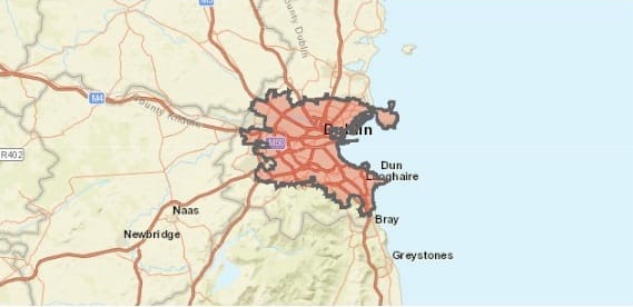
When we talk about Dublin, what geographical area are we talking about? Including within a city’s boundaries only areas with shared interests is key to success.

Did 6.7 percent, 7.5 percent, or 10.4 percent of all morning commuters in Dublin cycle to work in April 2016, the time of the latest census? That depends on which area you take to best represent Dublin.
Many people think the area of the Dublin Regional Authority (answer = 6.7 percent) is the place that matters most. The officially designated area comprises the four combined local authorities of Dublin City, Fingal, Dún Laoghaire-Rathdown, and South Dublin, and is essentially the same area as County Dublin.
That means it stretches from Garristown in the north to Kippure in the Dublin and Wicklow Mountains to the south. All lovely and beautiful places, but not particularly urban.
Others take the local authority area of Dublin City Council (answer = 10.4 percent) to be the best benchmark for reporting on urban matters. But the purely administrative boundary stops before you’d reach Walkinstown or Windy Arbour, surely as part of true-blue Dublin as anywhere else you can think of.
Actually, it is the middle statistic (answer = 7.5 percent) that is the most meaningful, as was correctly pointed out by Cian Ginty of the Irish Cycle blog.
In fact, it is the only one worth paying any attention to, and we need to spend a much greater amount of time thinking about it. The figure relates to an area defined by the Central Statistics Office as “Dublin City and Suburbs”.
Dublin City and Suburbs is the continuous and contiguous built-up urban area. It takes in the main city area, plus the suburban towns of Blanchardstown, Lucan, Clondalkin, and Tallaght. It is, if you like, the whole city and only the city.
Another way of explaining it might be as far as you can walk in any direction without having to pass through fields of open countryside
A few pertinent facts about it, while we’re here.
It has a population of 1,173,179 people recorded as resident on census night of Sunday 24 April 2016. The morning commuter mode share was 48 percent private vehicles, 23 percent public transport, and 29 percent active travel (of which 7.5 percent were cycling and 22 percent walking).
And it has a population density of about 3,500/sq km, according to the AIRO “Atlas of the Island of Ireland”. This is typical for a mid-sized European city. Supposedly densely urbanised Berlin has 3,930 people per sq km, taking the same proper definition of its urban boundary.
Not only does it seem to make good sense, but it is the proper and recognised way to define and measure an urban area.
The CSO take this definition of Dublin’s settlement footprint, because of what they call “the 100m rule”. From 2011, a census town was defined as being “a cluster with a minimum of 50 occupied dwellings, with a maximum distance between any dwelling and the building closest to it of 100 metres, and where there was evidence of an urban centre (shop, school etc)”.
According to Eurostat, “Economic activity, transport flows and air pollution clearly cross the
administrative boundaries of a city as well. Consequently, collecting data exclusively at core city level is insufficient.” Because the functional influences of a city go beyond its immediate boundaries, they seek to measure the “functional urban area”, or the urban footprint of the city.
As the late Paul Mees, one of the foremost transport theorists, put it in his indispensable text,
Transport for Suburbia: Beyond the Automobile Age, “when comparing the densities of cities, or parts of cities, it is important to use consistent definitions, count only urbanised land and count all the urbanised land”.
Not only is it the proper way to define and measure an urban area, but the cities that take it most seriously are also usually the most successful and sustainable ones.
Portland, Oregon, regarded as one of the most successful and sustainable of US metropolitan areas, has its city boundary enshrined in its state’s constitution. Extensions to it require a senate vote and this attitude has led to some significant successes in both transit and active travel.
The antonym of this is a city like Toronto, which has administrative boundaries that extend beyond the urban area, allowing outlying suburbs outvote the city on key issues such as taxation and infrastructure. Vide the erstwhile, controversial Mayor Rob Ford, who decried any investment in urban mobility. This is a long-standing problem in North American cities, although some analysts say that the metros are now making a comeback.
Anne Hidalgo’s mayoral remit, by contrast, is the city of Paris, whose urban electorate share her vision of a sustainable, automobile-reduced future. Sadiq Khan has similarly decided to place “Healthy Streets” and “Liveable Neighbourhoods” at the centre of his strategy for London.
To emulate them, Dublin would first need to do no less than take a lesson from Ireland’s second city. Cork County Council has, with considerable grace, agreed to cede land and a constituency of 160,000 people to the city, following the recommendations of the McKinnion Report. This to make the city stronger and allow the county council focus on its own distinct issues.
So is there such magnanimity to be had within Dublin’s four local authorities? There are surely many permutations for a directly elected mayor for Dublin.
But in this scenario, taking the city and its dwellers into account, the logical principle becomes an extension of the Dublin City Council administrative boundary to encapsulate all of Dublin City and Suburbs.
To really shake things up, give the lord mayor a five-year term, and – crucially – have the chief
executive officer (the individual more popularly known as the city manager) report to her or him.
It is even a moot point whether the lord mayor should become directly elected or remain indirectly elected by the council members as at present. Once executive authority is vested in the council, its election takes on a whole new meaning.
Then there are further variants. Why not give the current chairs of the council’s strategic policy committees (at present a position limited to persuasive power) executive or cabinet roles, working with the lord mayor (who might get to appoint them).
That kind of future would be different indeed. An accountable local authority steered by an individual with authority to speak for the city on the global stage and to champion a vision for the city locally.
It would raise the biggest questions for the remainder local authorities of the Greater Dublin Area.
Would Fingal – revealed to be the fastest-growing local authority in the country in the 2016 census figures – accept an independent future as a young, linear and coastal city stretching from the airport and connecting the largest and fastest-growing towns in the Eastern region.
Would those parts of South Dublin and Dún Laoghaire-Rathdown outside of the metropolitan boundary merge to become a natural-resource authority managing the riparian and upland amenities?
That is one of many possible visions, but if we are measuring the real progress of the city, there is only one area to look at: Dublin City and Suburbs.
And yes, cycling is the fastest growing mode and the figures are impressive. A plan – backed up by investment – to nurture that growth, and to provide a high-quality public-transport network, for the city and its suburbs, is badly needed. But who could deliver it?

The government should tell communities directly about plans for new asylum shelters, some activists and politicians say.


The current skirmish is over a Manna base at Junction 6 in Blanchardstown.

The idea is for this spot next to Dublin Castle to host choirs, chamber music, trad music, poetry performances, and more.