Advocates call for the full implementation of an expert report on special care, and welcomed plans for legal reform to get state agencies working together.
The government seems to be considering making helmets and hi-vis mandatory for people using some category of bikes, though it’s not totally clear which.
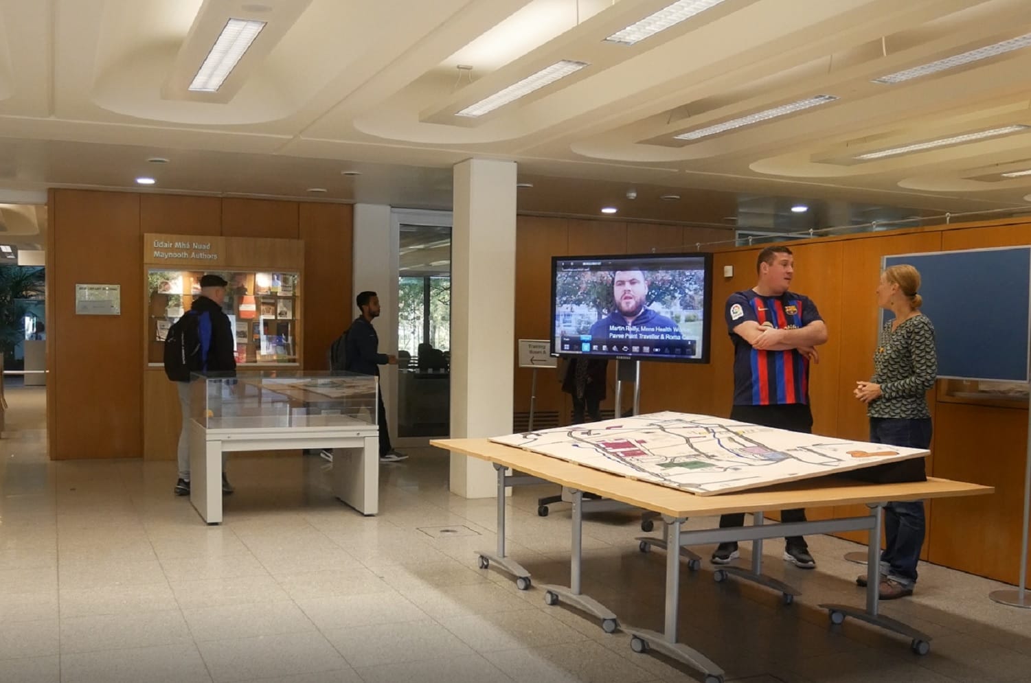
Michael Collins is standing in front of a big map of Coolock, laid out on a large table in the foyer of the library at Maynooth University.
Marked on wooden panels are loops of roads and the shaded outlines of 65 places that local Traveller researchers and participants have said are important to them, stickered with shiny stars and colourful dots.
For almost two years, researchers at TravAct in Coolock and Pavee Point Traveller and Roma Centre, alongside staff and students in the Geography Department of Maynooth University, have been working on this community map of Coolock.
Behind every star or dot is a story of belonging or unbelonging, and through workshops and events, those tales tumbled out.
Three generations of Travellers shared how they feel about places in the neighbourhood.
They placed stars on a giant map to mark positive experiences and spots to indicate negative ones – with different colours to represent different ages and genders.
“This captures change through time. Traditional maps are just a snapshot but these stories are also stories of change,” says Karen Till, a professor in cultural geography at Maynooth University.
The project is about recording heritage that would otherwise be lost and giving Travellers a chance to decide what is documented and remembered, says Collins, a Traveller men’s health worker at Pavee Point.
Says Till: “It’s trying to create maps in which the Travellers are central to the story, and that also is what we would call an anti-colonial practice, challenging these histories of racism and marginalisation.”
The Coolock mapping project grew out of a family-tree project with Travellers in Finglas, says Collins, of Pavee Point.
Through that, people had found that their families had come from the West of Ireland, into the Midlands and to Dublin.
As research for that, as well as any official records they could find, some of those involved talked with older Travellers.
One woman who they spoke with, Molly Collins, could recite her family tree back to the 1800s off the top of her head, he says. “Even where they were born. Even though they didn’t stay in the one place. Travellers back then travelled everywhere.”
Among the places she mentioned were the summer and winter camps on the outskirts of Edenderry in County Offaly. Places like Woody Cross Road, arched with trees for shelter.
They thought they should document those, says Collins, and so did that as part of another project, called Pavee Roads Home. “Because there’s no information there. Who knows these camps? The only people who knew these camps were the older Travellers.”
Michael Collins and Karen Till in the foyer of the library at Maynooth University. Photo by Lois Kapila.
Without documenting this heritage, it’s going to be lost, he says. Otherwise, what is documented about Travellers is left to and curated by others, by the Irish government or whoever.
The projects are also about pride against the onslaught of negativity and prejudice about Travellers, he says. “Because we’re trying to get young Travellers to be proud of the people they came from. There’s nothing to be ashamed of.”
Till, the professor at Maynooth University, who also worked on the Coolock mapping project, said that as a geographer, she is interested in how people make places.
Places are storied, and centres of meaning, memory and lived experience, she says, and not parcels of property, or just locations or sites on a global grid.
How people create those meanings, inhabit and story places can vary, she says. People whose ways of life and culture included moving, such as Travellers, along routes between camps and halting sites, were making places as they went, she says. “They told and shared stories about the places that were special for their people.”
Yet official maps, which are never neutral objective representations of reality, fail to capture these senses of place. “They depict the needs of the users and can be geopolitical weapons of oppression,” says Till.
With colonialism, land was surveyed and new ownership and property rules imposed, she says. “On these maps, places were not depicted as meaningful centres of meaning, experience, and memory for groups of people, but emptied out to become parcels of land that could be bought/sold on markets or gifted by the crown.”
And because of the histories of colonialism – which continued into the Irish Free State, unfortunately – people have been criminalised for moving around, and excluded from histories recorded through map-making, she says.
But there is such richness of knowledge within the Traveller community, she says. “And just because people are officially looking away, or not being inclusive doesn’t mean that people don’t exist and that they are not an important part of society.”
Over Time
Towards the middle of the map on the table is a shaded square for a local school. It is decorated with four stars and three red dots, marking both the differences in experiences of belonging and the passage of time.
Collins’ father, and daughter, came to take part in one of the workshops, says Collins. All of them went to the school, he says.
His father talked of his bad experience. “He had to take a shower every Monday morning, that was only for Travellers,” says Collins. “Even though his mother would have washed him, made him take a bath every Sunday evening.”
Travellers were separated into their own schoolyard, not allowed over the line into the settled people’s yard, he says.
There were corridor rules, that when settled children were walking down the corridor, Traveller children had to stand aside, up against the walls until they passed.
Things had changed by the time Collins got there himself, he said. There were no special showers and there was no Traveller-specific schoolyard.
But he was taken out for what were called special classes for Travellers, under the pretence of extra lessons, he says. “More than the majority of us didn’t need it, to be honest.”
At the time, he and his friends loved being hauled out of class for an hour a day, and left to play draughts or chess, or colour. “Brought into a doss class, as we used to call it.”
But he knows in the long-run it didn’t benefit them and just heightened exclusion, he says. “It was more kind of a tick box for the school.”
More recently still though, the school has changed, he says. His daughter would have had happier experiences there, and he would have been very involved in the school, and parent-teacher meetings, asking questions.
For Collins, the change over time on the map shows the importance of Traveller activism, and local Traveller-led projects like TravAct. “That’s what made the changes in the area,” he said.
Settled people have had some role by giving Travellers a seat at tables where decisions are made, he says. “And obviously working together and challenging stuff together.”
“But without the local Traveller project being there and challenging everything that they could challenge, a lot wouldn’t have changed,” says Collins, “and that’s really down to Travellers.”
A Conversation Starter
About 30 people came to events in May this year to either help with the mapping process, or rank their places of belonging and unbelonging.
The Traveller housing estates at St Dominic’s Park and Cara Park got mixed stickers. “So a lot of people felt belonging, and some people put down there unbelonging,” said Collins, glancing at the map.
People like being on the sites around their families, he says, hence the belonging. “But also the reason why of the unbelongings is because of the overcrowding.”
Many of the homes have mobile homes at the back, he says. “There’s nowhere else for them to go.”
The story map.
With no new Traveller accommodation being built, as people get older and get married, they end up moving back to the same place, he says. “When someone said that, other people were talking about that, it created a good discussion.”
As did conversations about the shops. Tesco also had a mixed response on the map.
“People use it for their shopping or the post office,” said Collins. But young Travellers feel they’re followed around when they go in and made to feel unwanted, he says.
Other landmarks sparked happier conversations. Even those that are now gone.
People talked of “Mr Monaghan’s shop”, a house with a container shop on the side. A lot of people had good experiences of it, says Collins, as the owner would take butter vouchers, and also let Travellers buy things on tic.
If payday was a couple of days off, but you needed bread and milk, he would give you a break, he says. “He built up a good trust with Travellers and Travellers also trusted him.”
After the map’s stint at the Maynooth University library, the plan is to move it back to the community where it was made.
The idea is to display it in the TravAct offices in Coolock, says Collins, so that when people come by for meetings – whether walk-ins or council officials, say – it can serve as a conversation starter.
Advocates call for the full implementation of an expert report on special care, and welcomed plans for legal reform to get state agencies working together.
The government seems to be considering making helmets and hi-vis mandatory for people using some category of bikes, though it’s not totally clear which.
“So the council is allowing horses in Dublin City,” says horse owner David Mulraney. “But they’re not allowing them to put their horse manure anywhere.”