What’s the best way to tell area residents about plans for a new asylum shelter nearby?
The government should tell communities directly about plans for new asylum shelters, some activists and politicians say.
The council has asked residents in an old part of town to weigh in on the current proposal.

On the morning of 12 February, Liam McMahon was walking through the thin and winding backstreets of Skerries.
From The Square, he turned onto Quay Street, a quaint and quiet residential road lined with terraced houses, their front doors just a few feet away from the road, with lots of cars parked up on the slim footpaths.
As it is, these streets are a tight squeeze for pedestrians, motorists and residents alike, he says. “People are literally out the door and on the street.”
It’s one of the older sections of the town. Parts of it are an architectural conservation area, he says. “Some of the houses around here, the houses, they’re sand.”
As a car approaches, McMahon has to step in against the wall to let it pass. “These roads here were designed for a horse and cart,” he says.
But Fingal County Council has grander ambitions for the Quay Street area down the line.
Officials are looking at how the routes around Quay Street, The Hoar Rock, The Square, North Strand and Pump Lane could become a new passage as part of the Fingal Coastal Way.
The Fingal Coastal Way is a proposed greenway travelling 32km from Newbridge Demesne in Donabate to the county boundary north of Balbriggan.
A long-standing objective in Fingal’s development plans and the Greater Dublin Area Cycle Network Plan, the greenway should provide a leisurely walking and cycling route through towns and countryside.
In January, residents in the Quay Street area were given a council survey showing eight options for traffic changes to make the greenway possible.
The council is currently seeking residents’ feedback on ways to deliver the coastal way by cutting through-traffic on these streets and prioritising pedestrians and cyclists, a council spokesperson said.
Many living around here, such as McMahon, are yet to be convinced of the route and are suggesting an alternative. Few people are against the greenway, he says. “They’re against how it’s being rammed down narrow, old streets, part of which is an architectural zone.”
Part of the challenge in teasing out and discussing the impacts of the current proposal is that possible designs and layouts aren’t yet available – like, how the space would be shared, what infrastructure added, and whether parking would be taken out.
In October 2022, the council published its emerging preferred route for this bit of the greenway through Skerries.
It would run up the coast, enter the area via the Balbriggan Road, starting at the North Strand and passing through Hoar Rock, before reaching Quay Street.
In his kitchen, McMahon pores over a large booklet, containing A3 maps for eight different options for traffic management that would be rolled out as part of the project.
His concern is that locals are being asked to pick from a set of traffic options which don’t give a clear picture of what the area will eventually look like.
The maps don’t show detail aside from possible traffic flows. “There’s nothing about parking being removed, or build-outs, or signage,” says McMahon. “You’re making a decision based on no information.”
The traffic-management plans propose variations on one-way and two-way traffic flows. Most options include putting a road block on Quay Street to divert motorists around the area, rather than through it.
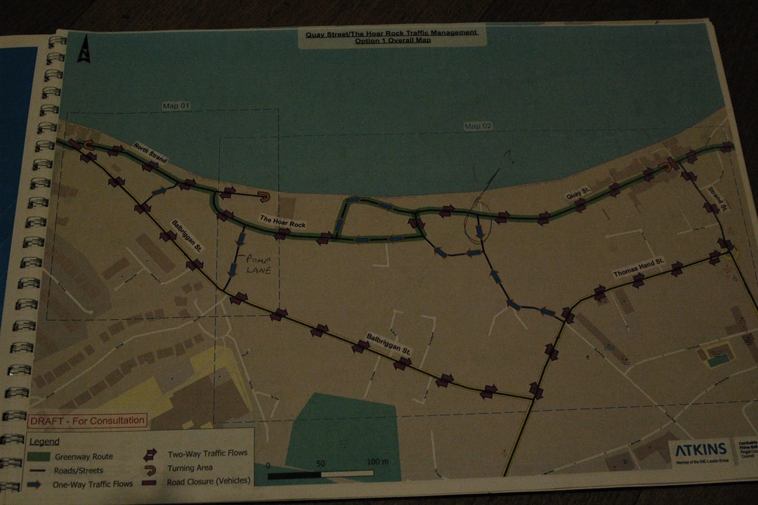
The potential cul-de-sacs are for motorised vehicles only, says the booklet, prepared by consultant group Atkins. “Pedestrians and cyclists will be able to travel freely through these areas.”
Residents in this area see the benefits to a greenway, says McMahon’s neighbour Kate Shiels. “We want to engage, and we want to find a meaningful solution, because we’re not saying no to the greenway.”
It’s how the council is routing the vehicles and bikes that concerns her, she says. “The plans show traffic flow through quite a narrow area with blind corners.”
What kind of redesign could accompany any changed flow isn’t clear, though. A June 2023 consultants report by Atkins says the proposed layout for Quay Street and the route isn’t decided, and would need local consultation.
The proposed design could be as simple as new route signage and road markings, or it could include new road and footpath layouts, it says.
Residents in the Quay Street area are considering a boycott of the council’s survey, said Fine Gael Councillor Tom O’Leary at the Balbriggan/Rush-Lusk/Swords Area Committee on 8 February.
O’Leary said he sees two pinch points, where a street narrows to a single lane.
“There are a lot of issues with this route. The residents feel it’s not safe. It’s challenging. They’re considering legal advice and might take a judicial review,” he said.
Safety was raised during the past public consultation, says a June 2023 consultation report.
But, the council document argued, the greenway would make the area more safe by removing some vehicle traffic and adding in better management – including of blind corners.
Residents had also flagged concerns that the greenway here would attract anti-social behaviour, would impact the heritage character of the area, worsen quality of life and remove parking spaces, the consultation report said.
The report’s authors rebuffed those concerns, though. Greenways don’t usually attract anti-social behaviour and bring eyes on the street, they said.
The street design was yet to be decided, they said, and also quietening streets by reducing vehicle traffic has a positive impact on quality of life.
They didn’t intend to change parking much, they said, and perhaps not at all.
At the meeting, O’Leary tabled a motion calling on the team involved in the Coastal Way project to engage with any proposals that emerge from the council’s Skerries Active Travel plan, which intends to improve walking and cycling routes in the town, as well as public transport.
If the council would wait for the Skerries Active Travel plan to be finished, it could show an alternative preferred route, said O’Leary in his motion.
Labour Councillor Brendan Ryan said the situation with planning in Skerries is unacceptable.
There are three projects underway in the seaside town, he said, pointing to the Coastal Way, Skerries Active Travel and Harbour Road, the latter of which proposes further active travel measures like pedestrianisation and a reduction in car parking near the pier.
All of these are being described as standalone projects, Ryan said, expressing concern that these were not integrated.
Linda Lally, a council senior engineer, said in a written response to O’Leary’s motion that the Skerries Active Travel Plan is a separate project to the Fingal Coastal Way, but that there is frequent internal consultation and coordination.
But, the Skerries Active Travel Plan is adaptable and will look at the links to the Coastal Way and all Active Travel initiatives, she said.
Chris McLelland, a Quay Street local, says he thinks there is a stronger alternative to the greenway’s current intended route.
As the greenway approaches Skerries from the north, it travels down the Balbriggan Road before following onto the North Strand and Hoar Rock.
McLelland says he thinks the better move would be to bypass this residential area altogether.
He points to the Barnageeragh Road, a long straight road which runs further inland. It would link the greenway in with both Skerries Mills and its station, he says. “That has cycle tracks on it already, and it’s a wide, green open space.”
McLelland points out that among the Coastal Way’s objectives is the improvement of access to public transport. “It is supposed to link to public transport and it doesn’t.”
Skerries’ train station is inland, about 1.3km west of the Hoar Rock.
He says that the alternative route is better connected for tourism. “It links straight to the train station, the tourist information office at Skerries Mills, which has a public car park and facilities. That’s something the greenway should do.”
The council’s 2023 consultation report says that its transport planners think that cyclists on the greenway are likely to head along the route that they have marked out though, given the attraction to landmarks such as Skerries Head.
“It is likely that any users travelling along the greenway would divert onto Quay Street and The Hoar Rock regardless of whether or not they are directed to do so as it provides a direct route to the areas of attraction in Skerries with low volumes of traffic and no requirement to navigate along nearby busy roads and junctions,” says the report.
Michael McKenna, of the Skerries Cycling Initiative, says his hope is that the council and locals can reach an agreement over the management of traffic. “Because it would be a shame if the whole project was delayed.”
McKenna’s primary interest is in seeing safer connections between Skerries, Loughshinny and Balbriggan for cyclists, he says. “So we can cycle between the towns.
The proposed alternative route for the greenway would push it out from the coast, and the council’s current proposals appear to be designed as to keep it close to the water, he says.
“And to maximise tourism, it brings it down to the Harbour Road where there’s lots of pubs and restaurants,” he says.
The Barnageeragh Road is a bypass to the town, he says. “It has become a very busy road, but there are a lot of housing estates joining it, and a lot of residents there would like to be able to feel safe cycling to the station at one end of that road.”
The alternative route has also won councillors’ backing. Green Party Councillor Karen Power spoke in favour of it at the recent area committee meeting.
Quay Street and Hoar Rock is a conservation area, she said. “There’s biodiversity issues there. A lot of houses don’t have foundations.”
The alternative greenway route passes the train station on the outskirts of the town to help cut the number of people driving to Skerries and the two main shopping streets, she said.
“So the route that I proposed has more economic benefits and it facilitates more local use,” said Power.
Power told the committee she cycles this other route daily. “I don’t use any of the routes that are proposed for the Fingal Coastal Way.”
Ellen Clarke, the council’s project liaison officer, said that the council hasn’t an alternative greenway route that could be rolled out in place of the emerging preferred route.
Making one would slow up the whole project, she said. “And if we hold up everything in Skerries, we hold up the entire Coastal Way and that’s for years,” she said.
A council spokesperson says that an application for the Coastal Way project is expected to be put before An Bord Pleanála in the second half of 2026.

The government should tell communities directly about plans for new asylum shelters, some activists and politicians say.


The current skirmish is over a Manna base at Junction 6 in Blanchardstown.

The idea is for this spot next to Dublin Castle to host choirs, chamber music, trad music, poetry performances, and more.
Get our latest headlines in one of them, and recommendations for things to do in Dublin in the other.