What’s the best way to tell area residents about plans for a new asylum shelter nearby?
The government should tell communities directly about plans for new asylum shelters, some activists and politicians say.
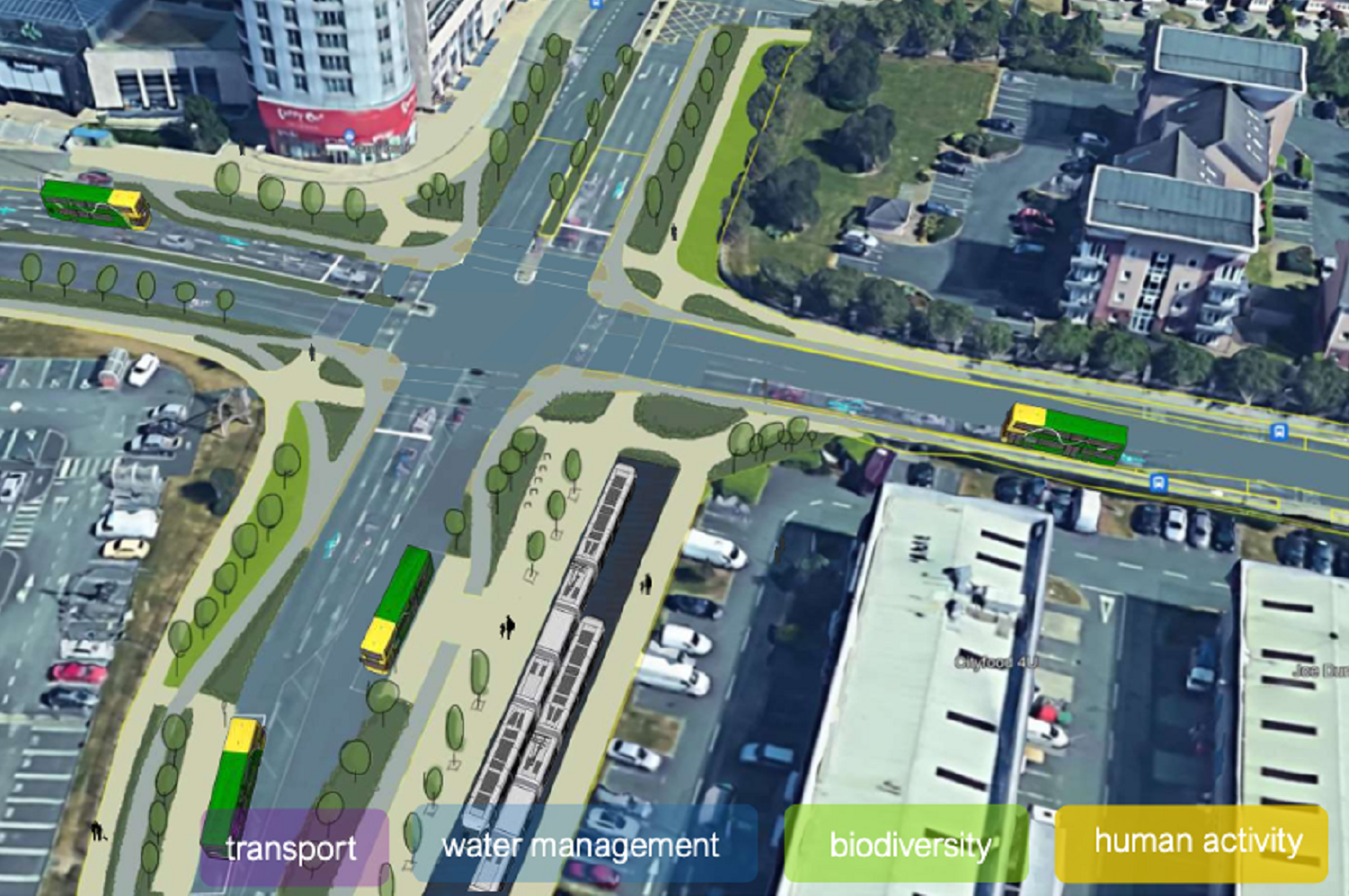
As part of extending the Luas Green Line to Finglas, Transport Infrastructure Ireland plans to make the Charlestown junction a bit better for public transport, cycling and walking.

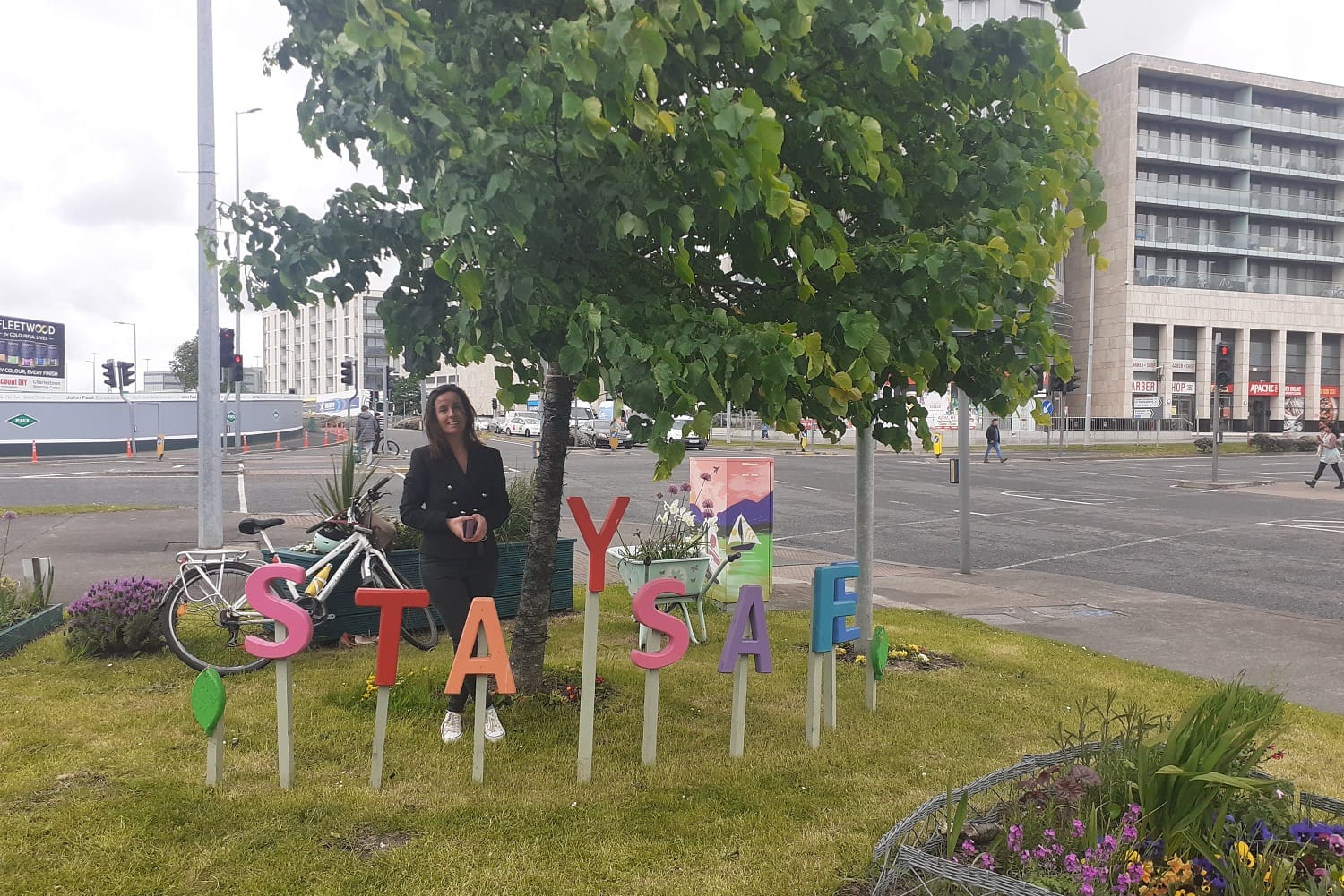
Yvonne Keogh kneels next to a wheelbarrow filled with flowers, refreshing the display with some new blooms.
The patch used to be overgrown, she says. She and other locals, with funding from Fingal County Council, brightened it up with flowers, an apple tree, planters and a colourful “Stay Safe” sign.
“It just brings a smile to everybody,” she says – and a small bit of quiet at the hectic junction opposite the Charlestown Shopping Centre.
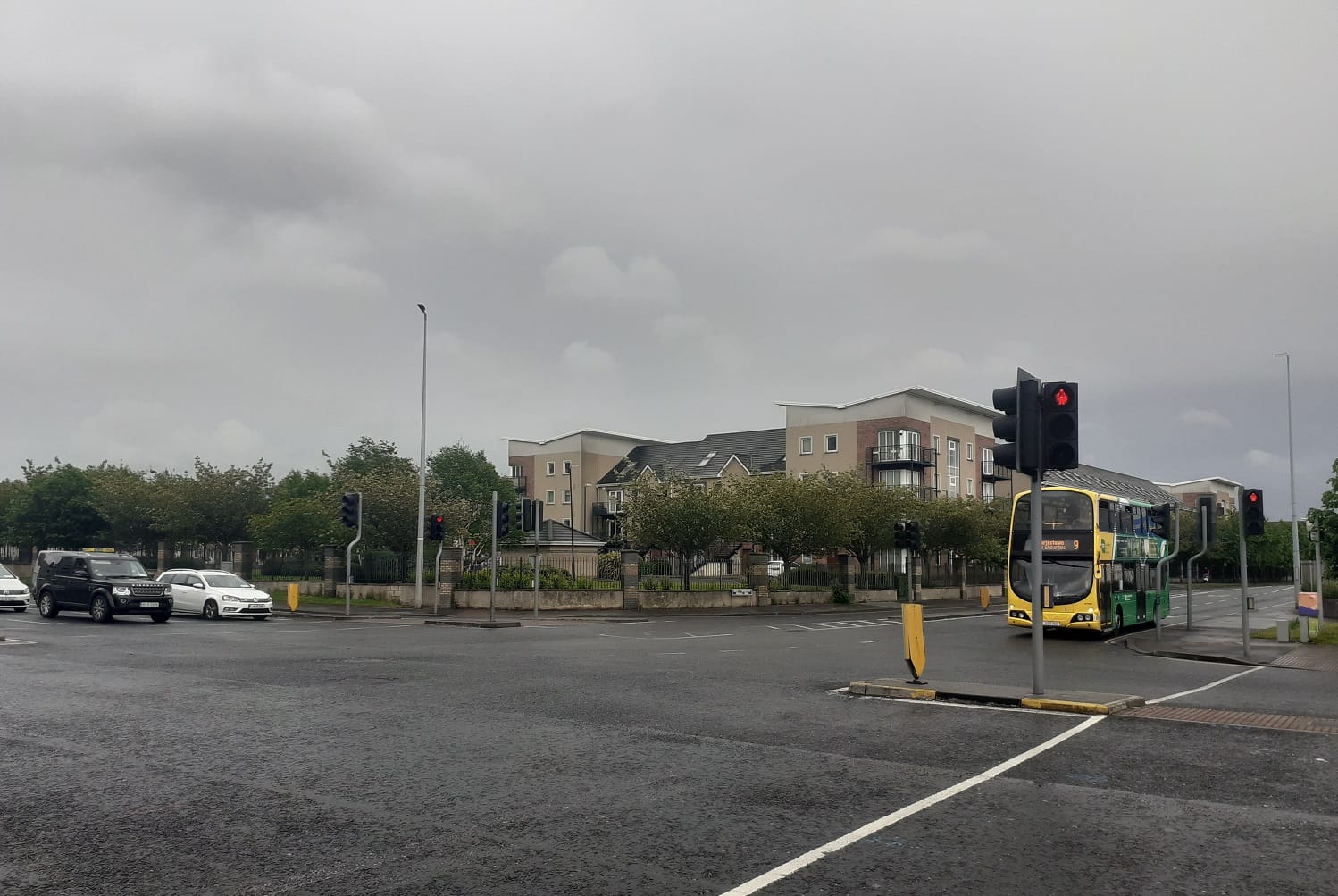
“Absolute chaos, I can’t tell you how dangerous it is,” says Keogh, looking out at the eight lanes of traffic travelling through to Finglas, Ballymun, Poppintree and St Margaret’s.
“It’s just concrete city,” she says. “We need to slow traffic, put things in place.”
A few weeks ago, Keogh met here with Eimear Fox, a landscape architect from Transport Infrastructure Ireland (TII).
They discussed plans for Luas Finglas, an extension of the Green Line to Charlestown, and the knock-on plans to change how the Charlestown junction works.
These would include removing one lane of traffic, adding bike lanes, trees and greenery, and making the area into more of a plaza and a destination, said Fox, in a recent presentation.
It’s part of the TII’s work to improve “transition zones” around the country, the stretches of roads close to village centres that are wide and car-focused, she said.
Keogh, at her colourful patch by the junction, says it would be a no-brainer to help kids and families to get around. “Because as you can see, it’s mental.”
A transition zone is the space along the road where it goes from a rural area to an urban one, said Fox, the TII landscape architect, in a webinar held by Engineers Ireland on 5 May.
It comes after a national road, and before a town centre, she said.
Transition zones sometimes have schools, sports clubs, churches, health facilities, open spaces, supermarkets and shops, and industrial areas, she says, but they aren’t usually very accessible by anything other than a car.
Partly, this is because of what drivers see when they approach the area, she says. Drivers sometimes aren’t told, through signage or road layout, that they should slow down for other road users.
“Generally in these areas, there’s excessively wide carriageways, there tends to be little active travel, and you know, quite poor sense of place, really,” she said.
But TII would like to redesign some roads so that people feel they can journey to and through there, and spend time in there, using other modes of transport besides a car, she says.
Changing transition zones would affect the work on improving the public realm in town centres, she says. “Is it counterproductive to spend money and time enhancing town centres if there are poor and clogged routes to hinder people from sustainably accessing them?”
Especially for transition zones that have schools in them, Fox says, where there could be more cycling and walking to reduce traffic, and areas for children to hang out outside the school.
“The more people are out and about, the less social isolation,” she says. “The more eyes on the street, the less crime.”
Transition zones normally have hedgerows and opportunities for more biodiversity, she says. But there could be more trees between the road and the footpaths, and trees have cooling effects, which is good for the climate – although tree roots are tricky around roads.
“We’re always getting the argument against trees, because of tree roots,” she says. “But if they’re designed and managed in, from the initial stage, they don’t necessarily have to be an issue.”
Fox and TII engineers had looked into transition zones in Finglas, Clare, Tipperary and Westmeath, and whether they could reduce the percentage of road taken up by space for cars, and reallocate it to bikes, pedestrians, and greenery.
Such as Grangemockler, a rural village in Tipperary which a national road runs through, that is dominated by traffic, says Fox.
At the moment, 79 percent of the 20-metre road width is carriageway for cars, while 11 percent is for pedestrians. Four percent is greenery, and the remaining 6 percent is paving shared by cars and pedestrians.
Some people walk to the shops locally, but on parts of the road, there isn’t a footpath, said Fox.
In TII’s redesign of the road, the size of the carriageway for cars was reduced to 45 percent, and the footpath was increased to 25 percent of the road. The greenery was increased from 4 percent to 13 percent, the shared paving to 14 percent and 3 percent was added car parking.
“There was a complaint from one person who said that putting the footpaths in meant they weren’t going to be able to drive right up to the door of the shop,” she said.
“These schemes can fall and rise on a couple of car parking spaces, it can be a huge barrier to approval, so it’s lesson learnt for us,” said Fox.
Dawid van der Spuy is walking to catch the bus to town on Melville Road. He compares Charlestown junction to O’Connell Street in the city centre, where cars are more aware that people will be crossing, he says.
“So it makes it safer to cross,” he says. “Whereas here, you need to be looking out for yourself. The cars are not looking for you. It’s more cars first, I would say, pedestrians second, is the feeling of the junction in comparison.”
Of the 13,692 sqm area of Charlestown junction, 55 percent is currently carriageway for cars and buses, said Fox. Meanwhile, 19 percent is for pedestrians, 24 percent is greenery, and 2 percent is for cycling.
In TII’s new designs for the junction, the car and bus carriageway would be reduced to 38 percent of the total area.
Pedestrians would be bumped up to 23 percent of the area, while cycleways would make up 9 percent, 5 percent would go to the Luas tracks and 1 percent to bus parking. Greenery would be increased to 25 percent.
“The biggest issue is we’ve taken space from the carriageway and given that back to public transport, and bus, and cycling, which is again, the key project objective,” said Fox.
The aim was to create a sense of place in the junction, she said. “Research shows that street trees and landscaping are among the top five factors determining people’s choice of walking routes to public transport, so creating place was really important.”
Although there isn’t more greenery, it would be used more functionally. “They’re used to direct people to crossings, to create a place, to separate the modes of transport,” Fox said.
Mary McCamley, a Labour councillor on Fingal County Council, says the proposed redesign of the junction would make the area better for people.
“For people to sit, it’s open air. You know, we learned this during the Covid that people like this,” she says. “Public realm, where people can sit out in plazas and squares. That’s the way to go.”
As part of the Luas Finglas extension, TII has drawn up preliminary designs for a terminus at Charlestown junction, including a plaza with greenery that will replace one lane of traffic on St. Margaret’s Road.
TII says Luas Finglas will reduce the journey time by bus from Charlestown to the city centre from 44 minutes to 30 minutes.
“Construction time depends on successful planning approval, ministerial approval and funding availability,” said Tom Manning, spokesperson for TII, last Monday. “The earliest the current programme allows construction to start is 2025.”
Keogh, in her green patch by the junction, says she thinks the designs would give people a sense of a community hub in the area.
She was happy to hear of the plans when she met with Fox. “I think she knows what we need here.”
Keogh is happy, too, to see that cycle lanes will be added to the area. “They need to do something. They haven’t been proactive on that.”
Across from the Charlestown Shopping Centre, is a construction site.
Puddenhill Property Limited has planning permission for 590 apartments, two shops, offices, a creche and a health centre there.
Keogh gestures to the rush of midday traffic zooming past her patch of flowers.
“It’s busy now, right, but see all this here. There’s probably about 24 blocks, there’s new ones opening there,” she says, pointing over at towers of apartments, and then the temporary walls bordering the site. “It’s going to bring the traffic up even more.”
Although she likes the plans to take away a lane of traffic, she’s worried about what more apartments will add to the deluge. “It’s quite mental really.”
Manning, a communications officer for TII, said detailed traffic modelling was done on the impact of the design on the roads, including the impact from future developments.
“While there may be impacts on local vehicular traffic movements the aim of the ?scheme is to use the project as an opportunity to build safe, segregated pedestrian paths along much of the route and deliver cycling infrastructure,” he said.
Fingal County Council and Dublin City Council did not respond to queries asking what plans are to manage traffic at this junction, located on the boundary between them.
John-Kingsley Onwumereh, a Fianna Fáil councillor on Fingal County Council, says he thinks the designs are positive.
Traffic impact assessments have been done, he says. “Having this new transport infrastructure would help mitigate [the traffic caused by] the growing population that is coming in.”
“The focus is changing from everybody driving to a little bit more active travel,” he says. “So that will take care of people who want to drive, and people might feel the need to walk down to the new plaza. I would hope that would be the case.”
Said McCamley, the Labour councillor: “It’s all about public transport and people getting out of their cars.”
People are excited to see the Luas coming to Charlestown, she says.“But we’re just hoping that these things will come, it’s very slow.”

The government should tell communities directly about plans for new asylum shelters, some activists and politicians say.


The current skirmish is over a Manna base at Junction 6 in Blanchardstown.

The idea is for this spot next to Dublin Castle to host choirs, chamber music, trad music, poetry performances, and more.
Get our latest headlines in one of them, and recommendations for things to do in Dublin in the other.