Vacancy Watch: a big site near Fatima Luas stop
Even as the government casts around for new land to zone for homes, it is unclear when this plot will be built out.
There’d be more space for pedestrians, cyclists, and outdoor dining. Some car parking spaces would be moved from Harbour Road further up the peninsula.

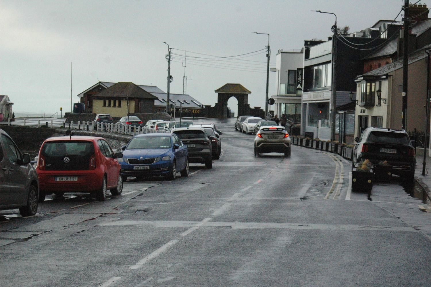
Few besides the fishermen and wagtails were willing to brave being out in rainy Skerries late on Monday afternoon.
The pubs along Harbour Road had filled up, and down at the Goat in the Boat café looking out towards the pier, soggy parents and kids had retreated indoors to wait for clearer skies.
With few pedestrians braving the downpour, the road that bends along the western side of the peninsula was almost exclusively occupied by parked cars.
Most had slotted into the designated spaces next to the low fence separating the street from the North Strand beach. The others took a spot over on the side of its sole footpath.
But most of those parking spaces may not be on the Harbour Road much longer, as Fingal County Council moves forward with a proposal to transform the peninsula into a spot that is more accommodating for cyclists and pedestrians.
The Harbour Road and Red Island loop would see cycling lanes going around the peninsula, with many of these Harbour Road parking spaces being moved further up the peninsula.
This loop would also connect in with the Fingal Coastal Way, a proposed greenway between Donabate and Balbriggan, Fine Gael Councillor Tom O’Leary said. “But a decision hasn’t been made on the greenway yet.”
For the Harbour Road, the council has suggested adding a new footpath, while the existing one is expanded and upgraded with more trees and outdoor dining.
It’s a popular area for locals, daytrippers and tourists, said Breen Doris, a senior executive engineer in the council’s active travel unit, at the Balbriggan/Rush-Lusk/ Swords Area Committee on 13 February.
But that path can’t handle all the footfall it gets during busy times, particularly at weekends, Doris said. “We’ve an awful lot of people meandering over and back across the streets, so that’s what we’re trying to tackle with this project.”
The idea is to push a lot of car parking spaces off the Harbour Road, and up around the corner, which could be better for businesses, Doris said.
The plan proposes to reduce the number of car parking spaces in Harbour Road from 50 to 25, while maintaining the same number (191) on the peninsula overall, according to a 6 February council presentation.
None of the local businesses, however, share Doris’s belief, and they all expressed this during the public consultation back in late autumn, says Joe May, the owner of Joe May’s pub on the road.
Among the 99 submissions to the public consultation on the scheme last autumn, however, there are positive comments.
“The street is for everyone to use, and it simply is not appropriate to continue using one of the most beautiful streets in Skerries as a glorified private carpark,” writes Shane Duffy.
“Stunning views of the harbour are blocked by parked cars, and pedestrians are squeezed onto poor quality footpaths that are far too narrow, and not suitable for buggies, prams, wheelchairs and other accessibility aids,” he writes.
So he’s pleased with most of the changes proposed by the scheme to open up the area for pedestrians and cyclists, including “the provision of a cycle track around Red Island, and I think this will become a valuable amenity”, he writes.
Following a public consultation between 11 September and 7 October, local councillors were presented with the council’s current proposal for the Harbour Road and Red Island loop.
It is an area with inadequate pedestrian and cycling facilities, as well as crossing points, said Doris of the active travel unit during the 13 February meeting.
The starting point of the loop is the Dorn, a small gravelly laneway that links the Harbour Road with Red Island Bay Beach.
Save for a clothes bank, the Dorn is disused and in need of an upgrade, Doris said. “This would be more of a public realm space where people can gather.”
Designs for the lane were also redone to accommodate the sailing club next door, so that they would be able to offload their boats and park their vehicles elsewhere, he said, “specifically on days where there would be a sailing event on”.
All along the Harbour Road, the proposal also suggested a traffic-calming scheme, he said.
Some car parking spaces would be kept outside the sailing club, with these being age and disability friendly, he said. “We’ve done away with the parking on the seaward side to provide a new footpath.”
An existing loading bay outside the 5Rock restaurant along the street would also be doubling up as a parking space during out-of-hours and the nighttime, he said.
But, one of the major ideas floated during this presentation is to close off the slip road onto the harbour to create a new public realm, he said.
Alterations have been made, however, to ensure that access is maintained for harbour users, he said.
On the issue of parking, the number of spaces on the Harbour Road will be reduced from 50 to 25, he said.
The existing parking spaces on the road weren’t adequate, he said. “They were opening out onto live traffic with no crossing points.”
Now, the council would be adding strategic crossing points where the “desire lines” are, he said.
But even if some of the parking spaces are being pushed off the Harbour Road, there wouldn’t be a net loss overall, he said.
New ones would go just around the corner at a more convenient point for businesses, including 13 EV-charging spaces.
On the eastern side of the peninsula at Red Island, the existing pathway is susceptible to flooding and needs an upgrade, he said, showing plans for both a pedestrian walkway as well as a three-metre-wide cycle lane.
A new link to the two-way cycle-path is also proposed at the top of the Harbour Road, he said, with these lanes running all along the north and eastern side of the peninsula, culminating back at the Dorn.
Some lighting will be provided up by the Martello Tower on this route around Red Island, he said, but during the consultation one issue that was raised was how lighting would affect the dark skies.
Stargazers raised concerns about how lighting might interfere with their ability to look out at the night sky at the north-eastern side of the island, in a spot known as The Captains, he said.
“So we’ve altered our public lighting design to cater for that and to remove the lighting in that particular section,” Doris said.
After this presentation, the next step is for the council to proceed with the Part 8 planning procedure, he said.
That’s when the council goes through a process of deciding whether to give itself planning permission for its own projects.
Originally, these new plans were due to go on public display before the end of February, but a council spokesperson on Tuesday confirmed that this was now due to occur on 4 March.
Fine Gael Councillor Tom O’Leary said at a local meeting earlier in the week that residents in the area were concerned that the reconfiguration of parking would mean a loss of green space up at Red Island – where spaces would be added.
Doris said removing some green space to add parking was something that was suggested by some of the residents during the public engagement. But they would also be trying to reclaim green space elsewhere, he said.
Sinn Féin Councillor Malachy Quinn said residents and business owners had legitimate concerns about pushing traffic up off Harbour Road and onto Red Island, as it could lead to people waiting up near the pier to park.
“People are going to do this, they’re going to sit and wait,” Quinn said.
But, currently, traffic is already being pushed onto Red Island from Harbour Road, Doris said. “Because there is no dedicated space on Harbour Road. I could drive down Harbour Road any day or night during the week, and not be guaranteed a space.”
It’s unfortunate, geographically that the parking is on the opposite end to where the intended destination point is, Doris said.
That can’t be changed, but the council can design around it, Doris said. “By doing that, we are reducing the traffic speeds throughout.”
Many of the aspects of this €6 million project were positive, Labour Councillor Brendan Ryan said at the meeting.
But as both Harbour Road and Red Island were key destinations for tourism, the project is unlikely to reduce the number of car trips to the area.
“Displacement of car parking from the seaside and Harbour Road creates problems for residents and businesses,” he said.
All of the local businesses were opposed to it, Ryan said.
A lot of the plan is good, but that removal of parking is a worry, says Joe May, the owner of Joe May’s Pub on the Harbour Road, whose family also owns the Stoop Your Head restaurant three doors down.
It’s going to reduce what is a well-used green space at the top of the Harbour Road, he said. “And you’re going to get two lanes for cycling there, plus a walkway, and a roundabout. It’s overkill.”
O’Leary, speaking on Saturday, said some of the businesses had said they are particularly concerned for elderly customers.
The five age friendly parking spaces down by the Sailing Club is one way that the council is trying to address that, he said, and there is also similar parking for people over 55 just north of Goat in the Boat.
Still, the reconfiguration could make for a nice dining area, with a pedestrian walkway on the seaward side of the Harbour Road, O’Leary said. “Lookit, there’s 191 car spaces now. There’s 191 car spaces when this is finished.”
There is still one last period for the public to offer an input as it goes on public display in early March before the council votes on the proposal, he said.

The island off Howth is a haven for puffins, cormorants, and more. But human visitors have continued to stress them.

Fingal County Council launched a feasibility study in 2017. But the project still requires further study, a spokesperson said this week.

Designers have new philosophies these days: more nature, natural colours, and trolls.

“It was subsequently recognised that this would be difficult to achieve … ,” says a Department of Transport spokesperson.