What’s the best way to tell area residents about plans for a new asylum shelter nearby?
The government should tell communities directly about plans for new asylum shelters, some activists and politicians say.
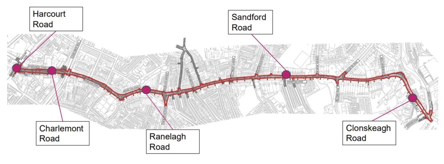
There would be one-way cycle lanes, separated from motor-vehicle lanes by kerbs, on either side of the 3.1km route from Charlemont to Clonskeagh Road.

Council officials hope to build segregated cycle lanes from Charlemont Street, through Ranelagh, and down to Clonskeagh Road, councillors on the South East Area Committee learnt on Monday.
There’s illegal parking and loading in cycle lanes along the route at the moment, said Niall Geraghty, a senior engineer from Aecom, at the meeting. The company was commissioned to design the pedestrian and walking improvements.
Much of the cycle route isn’t segregated and it stops and starts, said Geraghty. “There’s quite a bit of street furniture, some heritage columns, there’s also some trees.”
The scheme would fill in 3.1km of the city’s cycling network.
At the same meeting, Andy Walsh, a senior council engineer and head of its active travel unit, said his team is working on a detailed timeframe for building out the Greater Dublin Area Cycle Network Plan.
So far, 10km of 310km of the schemes in the plan have been built, he said. “Sounds very small, but it’s a start I suppose.”
“What we’re doing is all about trying to make a safer and more inclusive, sustainable environment for people,” said Walsh, explaining his team’s role.
“We also have a role in reducing carbon emissions, which everybody does, but we have a very clear and distinct role in that regard,” he said.
Geraghty, the Aecom engineer, said there should be a public consultation later this year on the Charlemont to Clonskeagh route, with preliminary designs done by September.
Much of 2023 would be spent on detailed design and procurement, with the project going out to tender at the end of the year, he said. “The construction then to take place hopefully in 2024, all going well.”
Aecom considered different options for the route, said Geraghty, including a two-way segregated cycle lane on one side of the road. But they settled for one-way lanes on either side of the route as best.
They looked at a shared cyclist-pedestrian space too, but aren’t going for it, he said. “To minimise pedestrian and cyclist conflict, so keep them separate basically.”
Along the 3.1km route are 11 junctions, said Geraghty. Under the scheme, they would add 17 new pedestrian crossings, he said.
The cycle lane would be at the edge of the road, at almost footpath height, and with a kerb running along it, he said. It would have buff surfacing, which is a softer paving, he said. “It’ll kind of brighten up the area with some additional planting as well going in.”
Tara Deacy, a Social Democrats councillor, said the elevated kerb designs looked lovely. “Will it look like that throughout the city?”
Geraghty listed many more changes. Lighting would be upgraded along the route, he said.
Thirteen of the 21 bus stops along the route would be made into island bus stops, meaning the cycle lane will run behind the bus stop.
Thirty-seven car parking spaces would need to be removed along the route, said Christopher Manzira, a council senior engineer for traffic planning.
“We are mindful that we are really constrained in this area in terms of space,” he said.
“We do not see a mechanism for us to retain that on-street parking. So it is a tough decision we will have to make in order to offer a continuous scheme,” said Manzira.
Said Geraghty: “There’s no reduction in disabled parking facilities and there’s no reduction in taxi-rank facilities.”
Dermot Lacey, a Labour councillor said: “I don’t think you’d have to provide, you know, on-street parking for every shopper and so forth, but it is a commercial district, so you do have to provide for parking for deliveries.
Manzira said alternative loading space for deliveries away from the main street is something they are actively looking into.
“We will be looking around-the-corner facilities to facilitate loading, because it is not possible within the main corridor itself,” he said.
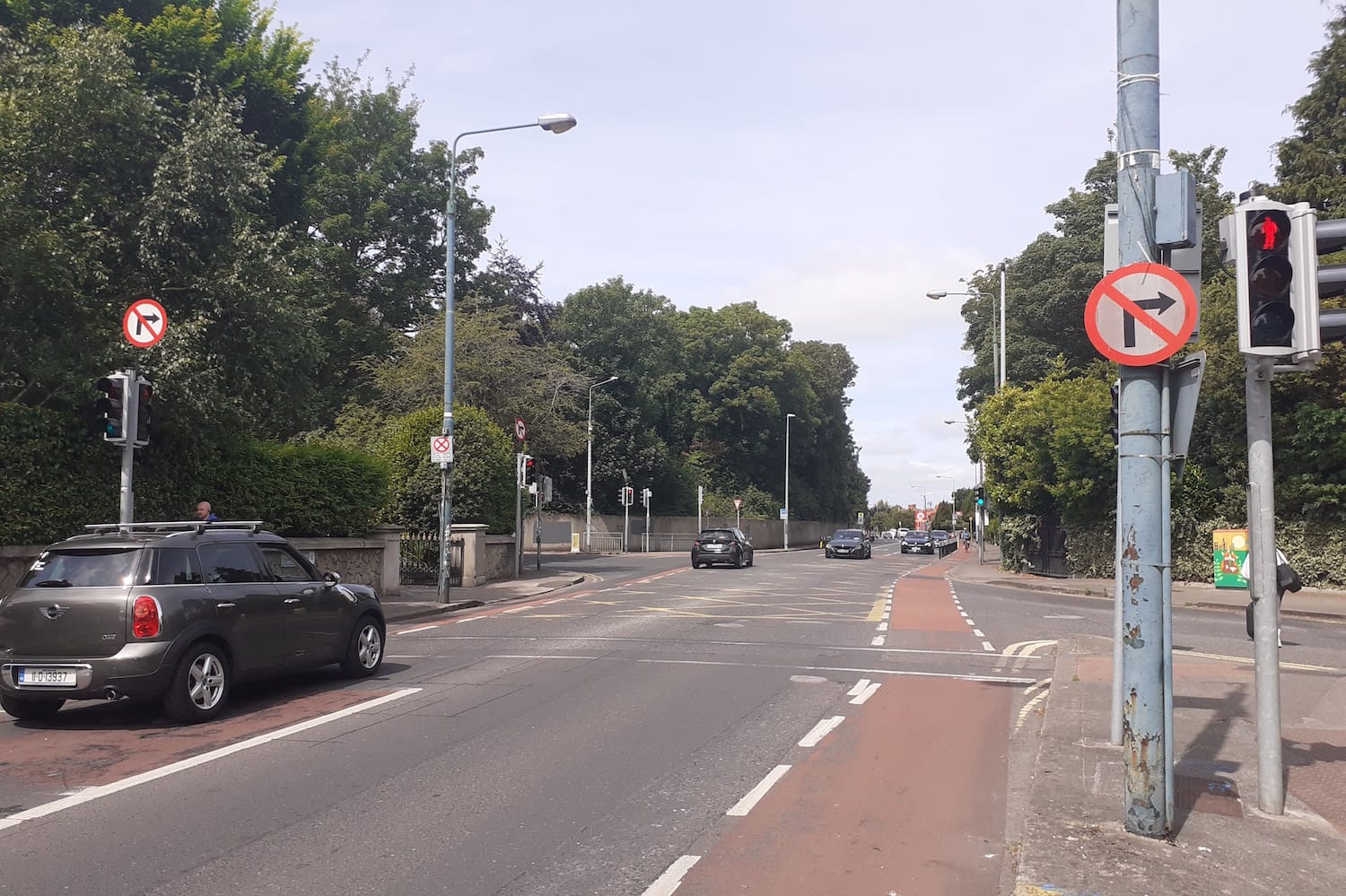
The council has already put in plastic bollards at some junctions, like where Milltown Road meets Eglinton Road, and the triangle junction on Ranelagh Road.
Grainne O’Brien, a council senior engineer, said those are temporary measures that they put in at certain spots along the route until the scheme is fully built.
“It’ll be like segregation measures such as bollards, road markings, plastic kerbs,” she said.
“In some cases we may need to change traffic layout and parking changes as well and improvements to some of the signalised junctions,” she said.
Manzira said the scheme would be funded by the National Transport Authority (NTA) under the active travel programme. “The cost of the scheme, at the moment we haven’t firmed up on that.”
The NTA allocated €300,000 to the scheme in 2022 as part of its active travel grants.
As other councillors have done, independent councillor Pat Dunne raised concerns about the geography of schemes that are moving ahead, complaining that some parts of the city are getting more money from the NTA’s active travel grants than others.
“One of the things that frustrates me as a councillor covering the Crumlin-Kimmage-Drimnagh area is that we have benefited very little from many of these projects,” Dunne said.

The government should tell communities directly about plans for new asylum shelters, some activists and politicians say.


The current skirmish is over a Manna base at Junction 6 in Blanchardstown.

The idea is for this spot next to Dublin Castle to host choirs, chamber music, trad music, poetry performances, and more.